- Home
- Platform
Platform
How ZYRNTOPO works.
Maps, terrain, your markers and your team's positions all live on the device. A connection adds to what you can do. You never need one to use the map.
Overview
Every app has the same tools inside.
ZYRNTOPO on Android, Windows, Linux and the web, and ZYRN Workstation on the desk, all carry the same parts: the map, offline storage, terrain tools, your markers and tracks, and plugins.
Online services are optional. Each one adds something when you can reach it, and nothing breaks when you can't.
Apps. ZYRNTOPO for Android, the web, Windows and Linux, and ZYRN Workstation for Windows and Linux.
On every device. The map, offline storage, terrain tools, your data, position, file formats, plugins and the license check.
Optional links. Team Sync, a TAK server, the local network, a mesh radio, MAVLink drones and online maps.
Offline
Download first, then go offline.
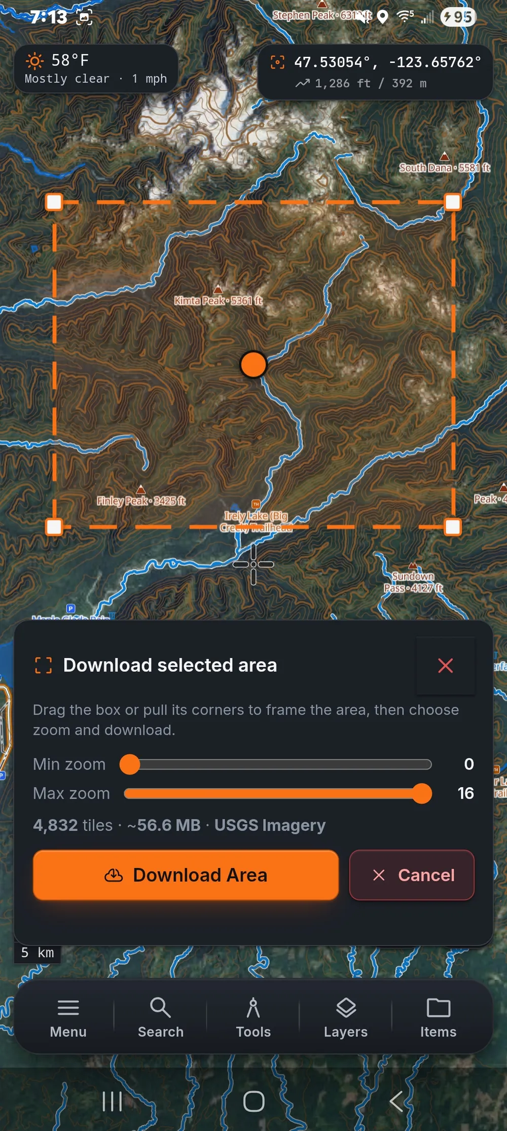
The map and navigation run on the device. A connection is used to sync, to download more maps and to link to other tools, never to keep the basics working.
- 1Prepare
Choose the area, zoom range and layers on any device.
- 2Download
Tiles and terrain for the area come down once.
- 3Store
Kept in persistent storage the system will not reclaim.
- 4Disconnect
No signal and no server, and the map still works.
- 5Navigate
GPS position, routes, bearings and MGRS on the device.
- 6Record
Tracks, markers, photos and notes are saved locally.
- 7Analyze
Slope, viewshed and profiles are computed on the device.
- 8Sync
When a link returns, changes go out and come in.
What stays on the device
- Map tiles
- Saved by area with a zoom range, a tile count and a size estimate before anything downloads
- Terrain
- Elevation for 3D terrain, slope, viewshed and profiles, saved with the area
- Points of interest
- Streamed on first launch and kept as an offline copy
- Your data
- Markers, lines, areas, tracks and photos, saved on the device and exported when you choose
- Pro license
- Verified on the device with a public key, so it keeps working with no signal
Terrain and 3D
See the terrain before you go.
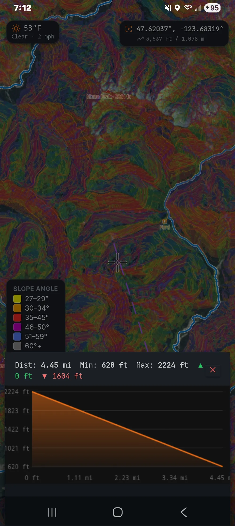
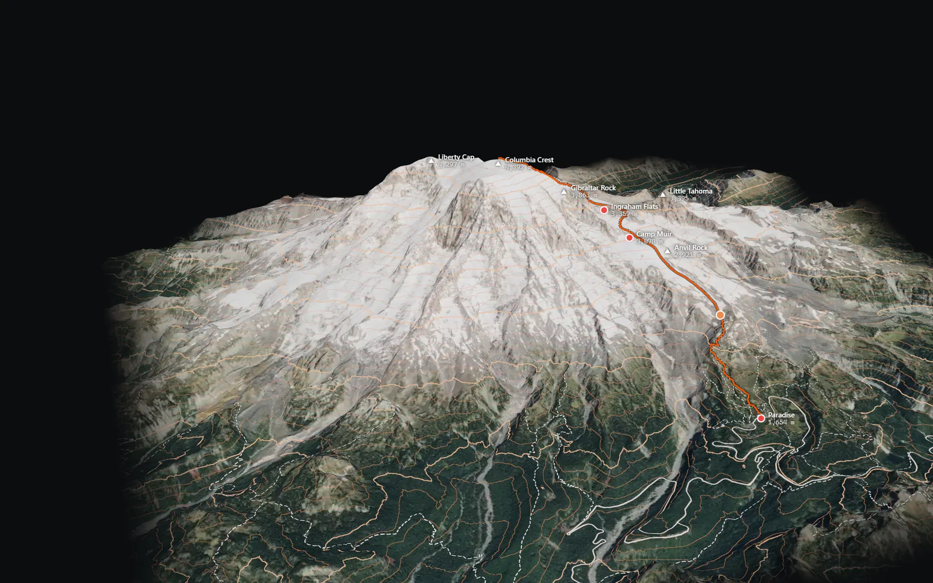
Elevation comes with the map. The same data powers the 3D view, slope shading, aspect, what's visible from a point, radio line of sight and every elevation profile you draw.
- 3D terrain on every platform, with terrain saved for offline use
- Slope classes from 27 to 60 degrees and above, for avalanche terrain
- What's visible from any point, and radio line of sight
- Elevation profiles with distance, minimum, maximum, gain and loss
- Contours, hillshade and the MGRS grid at every zoom
Teams
Share positions over the internet, Wi-Fi or radio.
Team Sync shares a live map, chat and positions over the internet. On the same network, nearby devices find each other, TAK devices included. A mesh radio carries positions where nothing else reaches.
- Team Sync
- Shared live map, Team Chat, invites and auto-reconnect Pro
- Nearby TAK
- Devices on the same network join automatically over multicast, with chat and map objects in both directions Pro
- TAK server
- A self-hosted server built on OpenTAKServer. ZYRNTOPO connects on port 8090, ATAK and WinTAK on 8089 Pro
- Mesh radio
- Meshtastic radios bridge into Team Sync, with no helper process Pro Beta
- Your own items
- Markers, lines and areas sync between your signed-in devices
Formats and links
Works with the files and tools teams already use.
Common file formats move data in and out on every device. You can add your own map services. Live links put TAK contacts and MAVLink drones on the same map as everything else.
| Format or protocol | Import | Export | Live | Notes |
|---|---|---|---|---|
| GPX | Yes | Yes | – | Tracks, routes and waypoints |
| KML and KMZ | Yes | Yes | – | Placemarks, lines and polygons |
| GeoJSON | Yes | Yes | – | Features with their properties |
| CSV | Yes | Yes | – | Points with coordinates |
| PDF map sheet | – | Yes | – | True scale, with grid, for the pack |
| WMS, WMTS, WFS | Yes | – | Yes | Your own map services as layers |
| Cursor on Target | – | – | Yes Pro | ATAK, WinTAK and TAK servers |
| MAVLink | – | – | Yes Pro | Drone position and status over UDP and serial |
| Meshtastic | – | – | Yes Pro Beta | Positions and chat over LoRa |
ATAK, TAK, MAVLink and Meshtastic are marks of their respective owners. Mentioning them here only means ZYRNTOPO works with them, not that we are affiliated with or endorsed by them.
Plugins
Plugins work in every app.
Plugins are small JavaScript add-ons. The same plugin runs in ZYRNTOPO and ZYRN Workstation, on a phone, in the browser or at the desk. Each one lists what it needs, and you see that list before it runs.
- Map
- Draw points, lines and GeoJSON, add tile layers, move the view, pick a point, read elevations
- Interface
- Toolbar buttons, menus, side panes with fields and lists, prompts and notifications
- Data
- Read and change map items, keep settings, read and save files the user chooses
- Links
- Fetch from declared hosts, open sockets, send and read Cursor on Target
plugin.json
{
  "id": "org.example.spot-elevation",
  "name": "Spot elevation",
  "version": "1.0.0",
  "apiLevel": 2,
  "permissions": []
}
main.js
const pane = zyrn.ui.pane({ title: 'Spot elevation', icon: 'terrain' });
pane.hint('Tap the map to read the ground there.');
pane.label('elev', 'Elevation', '-');

zyrn.map.on('click', async ({ lat, lon }) => {
  const [h] = await zyrn.map.elevation([{ lat, lon }]);
  const text = h == null ? 'No terrain here' : `${Math.round(h)} m`;
  pane.set('elev', text).show();
  zyrn.map.points('spot', [{ lat, lon, name: text }]);
});
A complete plugin. It needs no permissions because it only reads the map and draws on it.
Security and privacy
What leaves your device, and when.
The short version: ZYRNTOPO runs on your device, not on our servers. Here is what does leave it.
Read the full privacy policy- Location
- Stored on your device. It leaves only when you export it, share it in a Team Sync session, or use an online feature that needs coordinates, such as weather or routing.
- Usage ping
- About once a day the app sends the app version, the platform and a random device identifier. No personal data, no location, not linked to any account.
- Error reports
- When the app catches a crash it can send a short technical summary: the error, a stack snippet, the version and the platform. It can be turned off.
- Accounts
- Optional, for Pro and Team Sync identity. The email address is encrypted at rest. If our servers cannot be reached, the app continues without signing in.
- License
- Pro is verified on the device with a public key built into the app, so it keeps working with no signal and without contacting us.
- Installers
- The install commands check every download against its published SHA-256 and stop on a mismatch. Windows installers are not code-signed yet, which is why the checked command is the route we offer.
- No trackers
- No advertising, no third-party analytics SDKs and no cookies in the app.
Found a security problem? Email [email protected] with the details and how to reproduce it. Please give us a chance to fix it before you publish.
Try it on your own area.
Save an area, switch off the network and keep working.